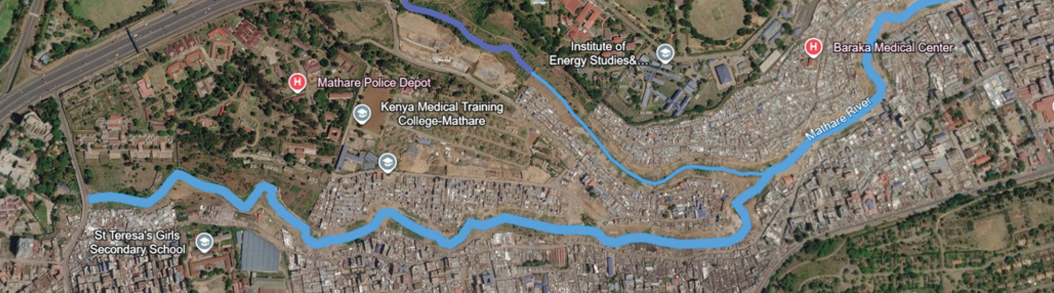
Mathare River Corridor Field Mission

Field survey and spatial diagnosis · Completed

Mathare River Corridor Field Mission

A URESA-LAB workstream based on the Kenya Mathare mission report, linking field data, territorial analysis and spatial design.

Project overview

Overview

The Mathare work documents flood risk as a systemic condition produced by spatial configurations, infrastructure failures, waste management practices and social inequalities. It uses direct observation, quantitative surveys, qualitative interviews and geospatial thinking to build a practical research foundation.

Objectives

  • Document spatial morphology, drainage conditions, waste accumulation and river corridor uses.
  • Connect field observations with geospatial analysis and contextual mapping.
  • Develop operational research outputs including morphography, physical models and spatial proposals.

Results

  • 883 respondents surveyed across Mathare villages.
  • Major flood drivers identified: waste accumulation, drainage obstruction, sanitation gaps and river overflows.
  • Roadmap defined for June 2026 to January 2027 research and public presentation.

Timeline

  • Kenya field mission and Mathare baseline
  • Territorial morphography and spatial diagnosis
  • Project presentation in Kenya and publication of results

Partners

  • Local Mathare leaders and youth organizations
  • University of Nairobi
  • Ministry of Lands and Physical Planning
  • National Youth Service
  • Civil society initiatives

Mathare research dossier

Methodology, field approach and conclusions

Section 01

Methodology and Field Approach of URESA-LAB

The URESA-LAB methodology adopts an interdisciplinary, field-oriented approach to analyze informal settlements exposed to environmental risks, particularly floods in riverine areas. This methodology rests on the belief that informal settlements constitute dynamic socio-spatial systems, within which urban form, environmental processes, and human activities interact continually. Rather than relying solely on secondary data or large-scale models, URESA-LAB prioritizes direct field engagement to grasp context-specific conditions at a fine spatial scale.

Field observation and spatial analysis

Systematic field observation is a central element of the methodology. On-site visits document the morphology of settlements, construction typologies, circulation patterns, and the relationships between homes, banks, and drainage infrastructures. Particular attention is given to the interface between built structures and hydraulic networks, including culverts, open channels, riverbeds, and retention areas.

Visual documentation, through photographs and sketches, helps identify spatial configurations, material conditions, and obstruction points affecting water flow and flood propagation. This qualitative reading highlights how informal construction practices adapt to environmental constraints, while showing how spatial organization contributes to both vulnerability and resilience. It also enables identifying fine-scale elements, such as waste accumulation zones and informal drainage networks, often absent from official maps.

Environmental assessment and risk identification

The methodology integrates basic environmental assessment techniques to identify factors contributing to flood risk. This includes observing fluvial morphology, sedimentation, water level marks, and signs of erosion along the banks. The presence and condition of drainage infrastructures are evaluated, with particular attention to obstructions caused by solid waste and to the reduction of hydraulic capacity in culverts and channels.

Flood risk is approached as a space-embedded phenomenon, shaped by natural processes and human activity. Rather than producing numerical flood models, the URESA-LAB approach prioritizes qualitative and spatial indicators of risk that can be directly observed in the field. These indicators provide information on recurrent flood mechanisms and the cumulative impact of small-scale obstructions on water movement.

Methodology and Field Approach of URESA-LAB

Section 02

URESA-LAB Methodology and Field Approach

Documentation of local adaptation practices

An essential aspect of the URESA-LAB field approach is to document the adaptation strategies employed by residents. In informal settlements, populations regularly modify their built environment to cope with flooding, notably by elevating ground levels, strengthening structures, or reorganizing circulation spaces. These adaptations are analyzed as concrete expressions of local knowledge and resilience.

By valuing these practices, the methodology goes beyond deficit-focused approaches and recognizes residents as active actors in environmental risk management. This perspective promotes a more inclusive understanding of resilience, based on daily practices rather than externally imposed solutions.

Integration with geospatial and analytical tools

If the Kenya mission is primarily based on field observation, the methodology aims to link these observations to geospatial analysis and mapping tools. On-site data complement satellite imagery, basic GIS layers, and contextual mapping, thus providing a multi-scale reading of flood risk. This integration helps close the gap between real conditions and abstract spatial representations.

In the long term, the URESA-LAB approach aims to incorporate data-driven environmental monitoring and analysis tools in informal contexts. However, for this mission, the emphasis is on establishing a qualitative and spatial baseline to support future analysis and monitoring work.

Methodological positioning

The Kenya mission is primarily based on field observation, while remaining designed to connect on-site observations to geospatial analysis and mapping tools. Field data can be used to complement satellite imagery, basic GIS layers, and contextual mapping, thus providing a multi-scale understanding of flood risk. This integration helps close the gap between real living conditions and abstract spatial representations.

The long-term objective of the URESA-LAB approach is to enable the integration of data-driven environmental monitoring and analyses in informal contexts. However, for this mission, the emphasis remains on establishing a qualitative and spatial baseline that will support future analysis and monitoring efforts.

Section picture

Section 03

Field Survey in Mathare

On-site observation of the river corridor

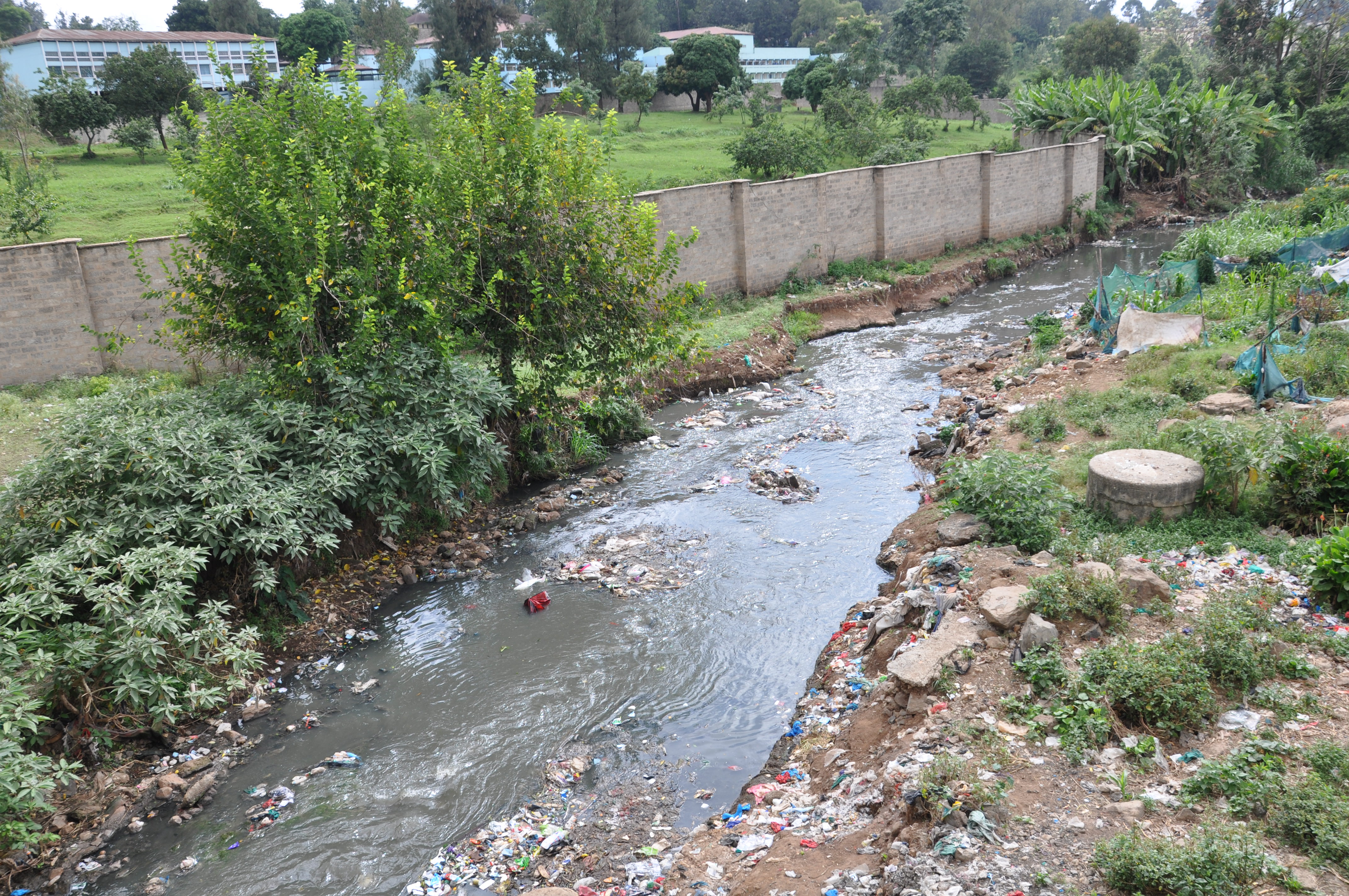
Field observations reveal that the Mathare river corridor is heavily degraded and under intense environmental pressure. About 70% of the corridor currently serves as an informal landfill, with more than 15 major waste accumulation sites identified along the banks.

Waste dumping into the river is continuous and systematic. Residents regularly throw their household waste directly into the river, and this practice extends to organized activities. Even during cleanup operations led by actors such as the National Youth Service, the collected waste is frequently dumped into the river, evidencing the lack of an effective waste management system.

The banks are also widely used as informal sanitation sites. Due to the lack of nearby sanitary facilities, open defecation occurs daily along the river. In some cases, existing sanitation facilities discharge effluents directly into the river, reinforcing the direct link between sanitation infrastructure and water pollution.

Waste accumulation areas are not only disposal sites but also informal economic activity spaces. Materials such as plastic, paper and organic waste are sorted and reused, thus fitting into small local enterprises. Livestock, notably cattle, goats and pigs, have been observed feeding within these waste deposits, highlighting the integration of waste into daily subsistence systems.

The vegetation along the river corridor is extremely limited, with fewer than 15 trees recorded, indicating a lack of ecological buffer zone and reduced environmental resilience.

Territorial conflicts and plurality of uses

The field study also identified zones of intense spatial conflicts, where several incompatible activities coexist in a very confined space. In some areas along the river, informal market activities, children's play areas, public toilets discharging directly into the river, illegal production of alcohol, and garbage dumps were observed simultaneously.

This overlap of functions creates extremely vulnerable environments, especially for children and other exposed groups. It illustrates the lack of land use planning regulations and highlights how river corridors become contested and multifunctional spaces in a context of scarcity.

Infrastructure deficits and environmental impact

The combination of survey data and field observations confirms that waste management is a key driver of flood risk. More than 20% of residents throw their waste directly into rivers or sewers, and more than 64% of respondents believe that waste accumulation contributes to flooding.

Furthermore, 71.9% of respondents report sewage overflows, indicating the limited capacity of sanitation networks. The river indeed serves as a final discharge point for solid and liquid waste, reducing its ability to drain stormwater and increasing the risk of overflow during rainfall.

Social consequences and service disruptions

Flooding has significant impacts on daily life. The survey results show that floods disrupt essential services, including water supply (78%), mobility (77.8%), sanitation (58.9%) and education (58.3%). Nearly half of households report income loss due to floods, and a significant number also report property damage and temporary displacement.

Access to water is already limited, most residents report irregular supply, and the situation worsens during floods. Additionally, about 29% of households report waterborne diseases, including diarrhea, malaria and cholera, highlighting the direct link between environmental conditions and health risks.

Qualitative interviews and institutional perspectives

The qualitative part of the study includes interviews conducted between April 12 and 15 with a diverse group of stakeholders, including local leaders, youth organizations, representatives of institutions, and professionals. These interviews included local leaders of Mathare Saint and Mathare Youth Talent, a candidate for Mlango Kubwa municipal elections, representatives of the University of Nairobi and the Ministry of Lands and Physical Planning, a field coordinator of the National Youth Service, leaders of local community initiatives such as Ujuane youth group, Heart Park and Miami Park, representatives of civil society organizations such as Face of Girls, and additional interviews with local actors.

These interviews highlight fragmentation of institutional responsibilities, insufficient coordination between official authorities and local actors, the lack of effective infrastructure systems, particularly in waste and sanitation, and the lack of preventive strategies with reliance on reactive measures. They also emphasize the importance of community initiatives and local engagement in managing daily environmental challenges.

Section picture

Section 04

Utilisations du Corridor Fluvial et Dynamique Observée

The Mathare River corridor is an extremely dynamic and contested space, where multiple informal uses coexist in a context of limited infrastructure and spatial constraints. Rather than functioning as a natural drainage system, the river has become a multifunctional space shaped by daily survival practices.

One of the main uses of the corridor is waste disposal: about 70% of the banks are occupied by informal dumps and more than 15 major waste sites have been identified. Waste is continually discharged into the river, even during organized cleaning operations, which attests to the absence of an effective waste management system.

The banks are also widely used for sanitation purposes. Due to the lack of nearby toilets, open defecation is common and, in some cases, sanitary facilities discharge their effluents directly into the river. This significantly contributes to water pollution and health risks.

Additionally, the corridor hosts informal economic and social activities, including waste sorting, livestock feeding, and the production of illegal alcohol. The vegetation is extremely sparse, with fewer than 15 trees recorded along the corridor, reducing ecological resilience.

Field observations also reveal strong spatial conflicts, where incompatible uses coexist in the same area, such as markets, playgrounds, dumps, sanitation flows and productive activities. This overlap creates conditions of high vulnerability, especially for children and local residents.

Overall, the river corridor reflects a situation where environmental degradation is closely linked to social practices and infrastructure gaps. The river serves as a drainage system, a waste disposal site, a sanitation space, and an economic resource, which increases flood risk and urban vulnerability.

Section picture

Section 05

Synthesis, Diagnostic and Main Conclusions

The combined analysis of quantitative data, field observations and qualitative interviews shows that flood risk in Mathare results from closely related environmental, spatial and socio-institutional factors.

Summary

The river corridor functions as a multifunctional system, serving as a drainage canal, a waste disposal site, a sanitation space and an area of informal economic activity. These overlapping uses reflect the lack of infrastructure and spatial regulation, but also the adaptation strategies implemented by residents facing limited resources.

The quantitative survey confirms generalized exposure to floods, the frequency of floods and the significant impact of waste accumulation and the insufficiency of drainage systems.

Diagnostic

The diagnosis highlights three major structural problems: infrastructure failure, spatial vulnerability and governance gaps. The inadequacy of drainage, sanitation and waste management systems leads to ongoing environmental degradation. Housing near the river, on slopes or in low-lying areas increases exposure to flood risk. The lack of coordination between institutions and the absence of effective service delivery limit risk mitigation.

In this context, the river becomes the last receptacle for waste and wastewater, which greatly reduces its capacity to manage stormwater flows.

Main conclusions

Floods in Mathare constitute a structural problem, not just a natural phenomenon. Waste accumulation and obstruction of canals are major flood risk factors. The river corridor is a highly contested space, characterized by multiple incompatible uses. Sanitation gaps directly contribute to environmental and health risks. Residents are highly vulnerable, but also have local capacity for action.

Overall, the results show that flood risk results from the interaction of daily practices, spatial conditions and infrastructural constraints. To address it, integrated strategies at multiple scales and community-focused methods must be implemented.

Section picture

Section 06

Action Plan and Research Perspectives

The next phase of this research is structured around the URESA-LAB methodological framework, which aims to link field data, spatial analysis, and experimentation through the project. This phase constitutes a crucial step to test and consolidate a scientific approach dedicated to understanding and transforming informal neighborhoods, using Mathare as the main case study.

Action plan

The research and design process is organized over a six-month period, starting in June 2026, with final results expected by January 2027, when they will be made public.

Development of a territorial morphography

A central objective is the production of a detailed territorial morphography of Mathare. This work aims to reveal the spatial logic of the informal settlement, highlighting density dynamics, infrastructure networks, environmental systems, and daily practices. This morphography is both an analytical tool and a standalone scientific output.

Focusing on Mlango Kubwa: vertical shantytown strategy

A particular focus will be placed on the village of Mlango Kubwa. In this context, the project will explore a vertical shantytown strategy as an alternative spatial model, addressing issues of density, land scarcity, and environmental pressure, while proposing new forms of urban organization.

Spatial proposals for the river corridor

Building on the previous analyses, the project will develop spatial interventions for the Mathare river corridor, addressing waste management dynamics, sanitation conditions, and flood risk. The aim is to requalify the corridor as a structuring element of resilience, rather than a space of degradation.

Production of physical models and visual materials

In the advanced stages of the process, a physical mock-up will be produced to synthesize the morphography and proposed interventions. This tool aims to facilitate communication, discussion, and validation of the project with local actors and partners.

A key step in this process is the planned project presentation in Kenya in November 2026. This moment is designed as a platform for exchange, allowing the presentation of the main results, notably the morphography, the vertical shantytown strategy, and the proposals for the river corridor to local actors, institutions, and partners.

Research perspectives

Beyond the immediate project framework, this work is part of a broader research trajectory developed by URESA-LAB. The implementation of the URESA-LAB methodological framework in Mathare represents a large-scale test of its scientific relevance, combining quantitative data, field observations and spatial design. The production of morphography constitutes a central contribution to this approach.

The project aims to open opportunities for collaboration with researchers and institutions, with the goal of contributing to relevant academic publications as well as interdisciplinary research on informal neighborhoods. The Mathare case study is a first step toward developing transferable methods that could extend to other urban contexts, especially in regions facing similar challenges, such as West Africa.

The presentation in Kenya will play a key role in integrating feedback from local stakeholders, to ensure that the proposed methodology and strategies remain grounded in real conditions and practices.

Positioning of URESA-LAB

URESA-LAB was developed in response to the growing complexity of urbanization in Global South countries. Its approach rests on data integration, fieldwork, and spatial design, with particular attention to understanding territories.

The work conducted in Mathare confirms that flood risk is not just a hydrological phenomenon but a systemic condition produced by spatial configurations, infrastructure failures, waste management practices, and social inequalities. This action plan thus reflects a transition from analysis to operational research, positioning the project as a contribution to a broader effort to develop new tools and knowledge for resilient and inclusive urban development.

Section picture

Project media

Project gallery

Mathare River Corridor Field Mission